Read Time 5 mins
05/06/2024
Advancing Precision Mapping with Sub-250g Drones at Carrot Drone Services
Introduction
In the swiftly evolving world of geospatial surveying, drone mapping stands out as a revolutionary technology that promises extensive data collection with unprecedented ease and speed. Yet, despite its potential, the adoption of drone technology in professional mapping and surveying has been tempered by significant hurdles. High equipment costs and stringent regulations imposed by the Civil Aviation Authority (CAA) often pose substantial challenges to operators. These restrictions are particularly stringent for traditional, heavier drones which require rigorous adherence to operational limits, thus inflating costs and limiting flexibility in deployment.
This introduction sets the stage for a discussion on how Carrot Drone Services is pioneering cost-effective and regulatory-friendly solutions in drone technology, making high-accuracy mapping accessible to a broader range of clients and projectsby utitlising sub 250g drones.
The Current State of Drone Mapping
Drone mapping technology has traditionally been dominated by high-end enterprise drones, engineered to offer extensive capabilities across various applications including agriculture, real estate, and civil engineering. These systems, while robust, come with a hefty price tag, often requiring a significant upfront investment in hardware, software, and specialised training. The sophistication of these drones translates into high maintenance and operational costs, making them a less viable option for smaller firms or infrequent users.
Regulatory compliance adds another layer of complexity to the use of traditional drone technology. In the UK, the Civil Aviation Authority (CAA) imposes strict regulations on drone flights, particularly those involving heavier drones that exceed 250 grams in weight. These regulations mandate maintaining a certain distance from people, severely limiting the operational flexibility necessary for urban and populated area mappings. The need for additional permissions further complicate the deployment of these drones, especially in sensitive or densely populated areas.
These financial and regulatory barriers have historically restricted access to drone technology, confining it to larger corporations or highly specialised service providers. This limitation has stymied broader adoption and innovation within the industry, impacting the potential scale and efficiency benefits that drone technology could otherwise offer.
Achieving Precision within Industry Standards
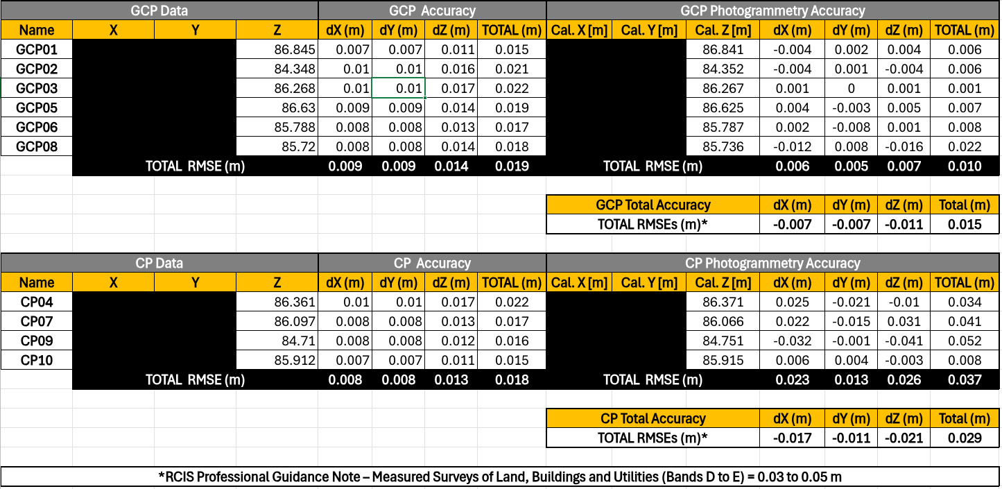
The commitment of Carrot Drone Services to deliver superior mapping solutions is evident in our adherence to and surpassing of the Royal Institution of Chartered Surveyors (RICS) standards. RICS sets the benchmark for accuracy in surveying, requiring that data collected for mapping purposes must meet stringent precision thresholds to be considered reliable for professional use.
Using the DJI Mini 3 Pro along with the Trimble DA2 GNSS Receiver equipped with Catalyst correction technology, Carrot Drone Services consistently achieves accuracies well within the centimeter range. These levels of precision ensure compliance with the RICS standards, which generally stipulate that survey data should have no more than a 5 centimeters of deviation from true positional accuracy to be deemed acceptable for most commercial and residential applications.
Meeting these standards is crucial for our clients, as it not only ensures the reliability of the data but also enhances the credibility of the survey results. For industries where accurate land measurement and analysis are critical—such as construction, real estate development and environmental planning—the ability to rely on precise data can significantly influence project outcomes, risk management and planning processes.
Moreover, achieving such high levels of accuracy with a lightweight and more flexible drone setup provides our clients with an advantageous blend of compliance, cost-efficiency and adaptability. This capability enables them to undertake complex mapping projects that were previously not feasible due to either financial constraints or regulatory limitations.
Request an Example Dataset
Are you interested in seeing the quality and detail of our drone mapping work firsthand? We believe in the power of our technology and the precision of our data, and we are pleased to offer example datasets to prospective clients.
An example dataset can provide you with a clear insight into the accuracy, resolution, and overall quality of the data Carrot Drone Services can deliver. Whether you are involved in construction, environmental management, real estate, or other fields requiring detailed geographical data, our samples can help you make an informed decision about utilizing our services for your projects.
Request a DatasetTraining and Development
Continuous professional development is a cornerstone of excellence at Carrot Drone Services. A pivotal element of our training regime included participation in a specialized drone mapping and surveying course conducted by Andy Carman of ARC Aerial Imaging. This course is renowned for its comprehensive coverage of the latest techniques and technologies in drone mapping.
The insights gained from this training have profoundly enhanced our technical capabilities. Andy’s course provided in-depth knowledge of advanced geographic data collection, processing strategies and the practical application of drones in complex mapping scenarios. This education has equipped our team with the skills necessary to tackle a wide range of projects, increasing our adaptability and the scope of services we offer.
Implementing the cutting-edge techniques learned from the course has allowed us to refine our workflow, improve data accuracy and reduce operational costs. These improvements directly benefit our clients by providing them with more reliable data, quicker project turnaround times and cost-effective service options.
Moreover, the ongoing engagement with industry-leading experts like Andy ensures that Carrot Drone Services remains at the forefront of technological advancements in drone mapping. It signifies our commitment not only to maintaining high standards of service but also to pushing the boundaries of what can be achieved with drone technology in surveying and mapping.
Showcasing Success
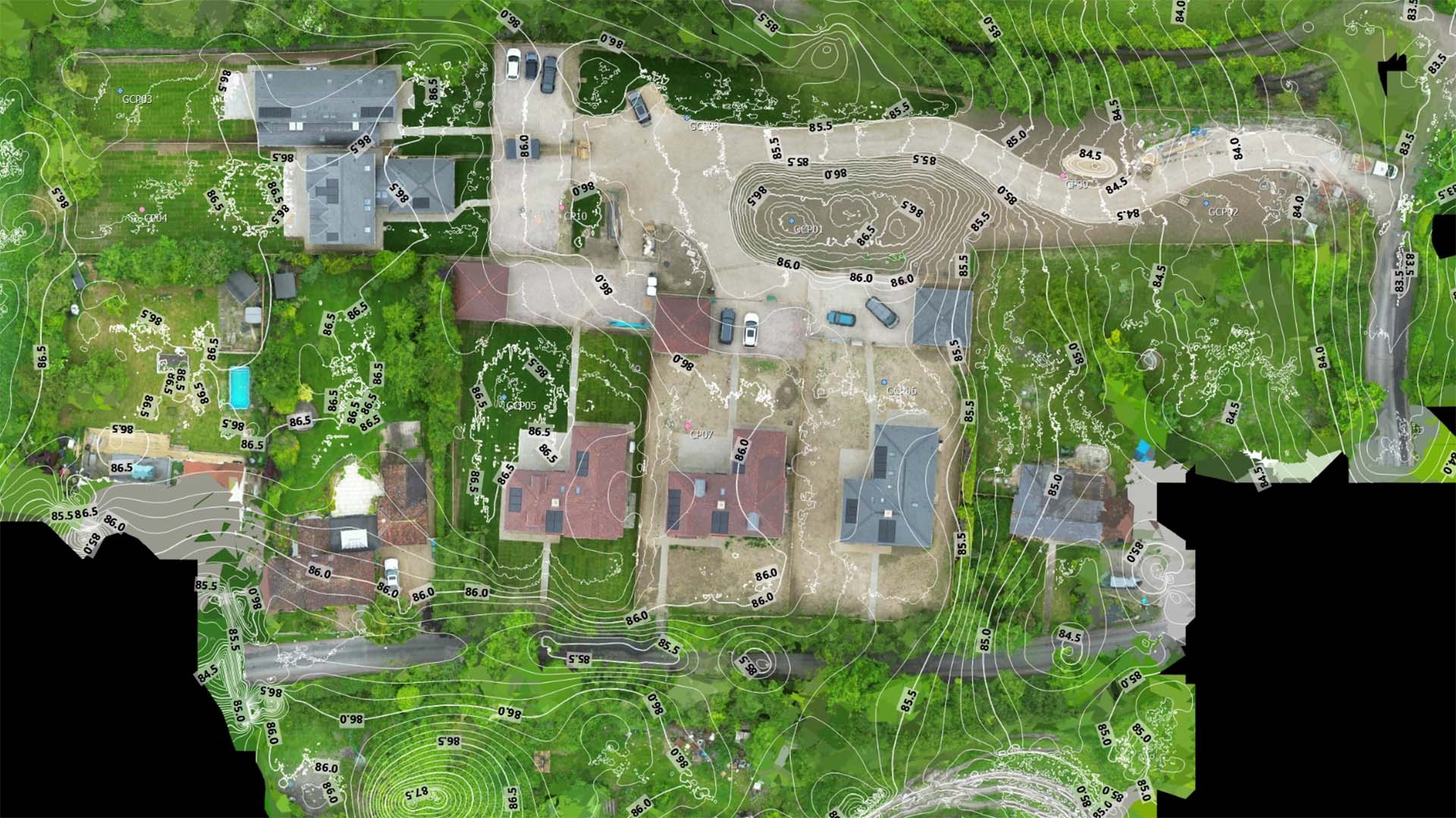
At Carrot Drone Services, we take pride in our ability to deliver high-quality mapping results across a variety of industries. One notable project involved detailed topographical mapping for a large-scale residential development. Utilising our DJI Mini 3 Pro and Trimble DA2 setup, we provided the developers with precise elevation data and boundary measurements, which were crucial for the planning and construction phases of the project.
Another significant achievement was in the field of environmental conservation, where we conducted habitat mapping in a protected area. The data collected has been instrumental for ecologists to monitor wildlife populations and vegetation health, contributing to ongoing conservation efforts. Our approach allowed for a minimally invasive survey that preserved the integrity of the sensitive environment.
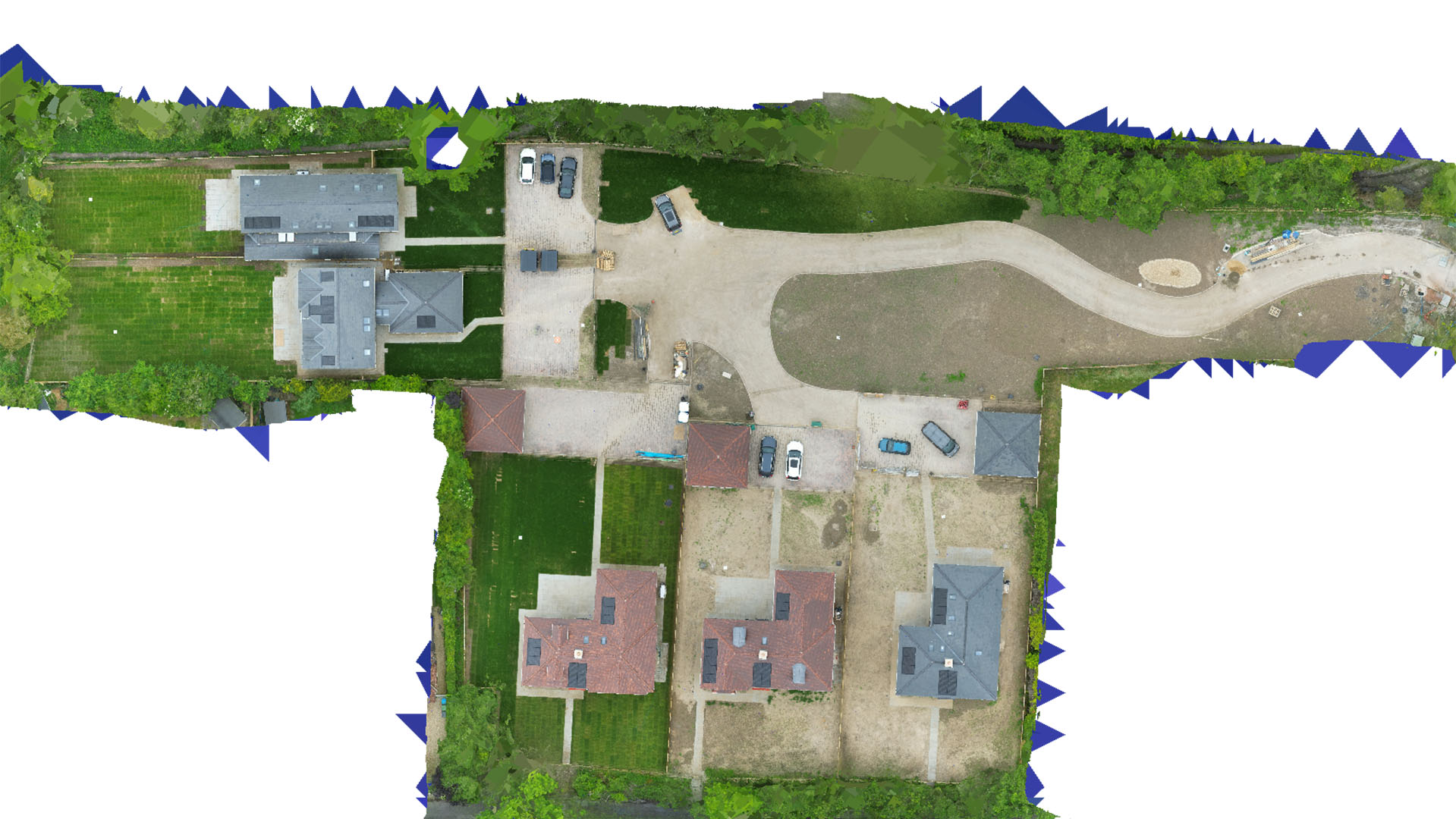
Each project we undertake is handled with the utmost confidentiality and precision. To illustrate the quality of our work while respecting the privacy of our clients, below is an anonymized image of a mapping output. This image demonstrates the detailed resolution and accuracy we achieve, though specific location coordinates have been blacked out.
Conclusion
Throughout this blog, we've explored the transformative approach Carrot Drone Services employs to deliver high-quality, cost-effective drone mapping solutions. By integrating the lightweight DJI Mini 3 Pro with the advanced Trimble DA2 GNSS Receiver and Catalyst correction technology, we have successfully navigated the challenges of costly equipment and restrictive CAA regulations. Our innovative method not only aligns with but exceeds the rigorous accuracy standards set by the RICS, ensuring that our data is reliable and precise.
Our commitment to continuous professional development, exemplified by our training with industry experts like Andy Carman, enhances our technical capabilities and service range. This ensures that we remain at the cutting edge of drone mapping technology, ready to adapt to and embrace new advancements.
The success stories shared demonstrate the versatile application of our services across various sectors, including residential development and environmental conservation, highlighting our ability to manage and execute projects that meet and exceed client expectations.
Choosing Carrot Drone Services means partnering with a leader in drone mapping technology that is dedicated to providing efficient, accurate, and regulatory-compliant mapping solutions. We are committed to helping our clients achieve their project goals with the highest level of service and expertise.
For more information or to discuss your specific mapping needs, please contact us today. Let us help you capture the data you need to succeed.
Get in Touch
Ready to elevate the precision of your projects with leading-edge drone mapping technology? Carrot Drone Services is here to deliver tailored, high-resolution mapping solutions that fit your specific needs. Whether you’re planning a construction project, conducting environmental research, or need detailed land surveys, our expert team is equipped to provide accurate, efficient, and cost-effective services.
Don’t let traditional mapping challenges hold back your projects. Embrace the future of drone mapping with Carrot Drone Services. Contact us today to discuss how we can assist you in achieving optimal results with precision and ease.
Contact Carrot Drone Services now to start discussing your drone mapping needs and see how we can make a difference in your projects.